Project Summary
The Cornwall AONB Partnership aims to channel private finance into nature across Section 08 of the Cornwall Area of Outstanding Natural Beauty (AONB), which is one of 12 sections of the AONB that cover 958 square kilometres. In 2020, the project team – Gain Consulting, University of Exeter and FWAG Southwest – found that a net environmental gain of up to £15.8m could be generated through its Landscape Recovery Framework, developed in partnership with 11 farmers in the AONB and other key stakeholders.
Throughout 2022, the project continued with grant funding from the Natural Environment Investment Readiness Fund (NEIRF). The project team has explored the feasibility of private investment into the farming sector and how to build the ‘supply-side’ of the project’s model. You can find full detail of the NEIRF project on its website, published by Cornwall AONB.
Acknowledgements
With many thanks to the following individuals for their time and insight:
Melodie Manners, Business Development Officer, Cornwall Area of Outstanding Natural Beauty
Collette Beckham, Director, Gain Consulting
![]()
Dr Grace Twiston-Davies, Research Fellow, Environment and Sustainability Institute, University of Exeter

Chris Knight, Director and Co-Founder, Terranomics
Tom Chellew, Senior Associate, Terranomics
![]()
Date Published: 08/12/2022
Initial mandate
This project was first developed as part of a wider programme to inform the Department of Environment, Agriculture, Food and Rural Affairs (Defra’s) design of the Environmental Land Management schemes (ELMs).
In light of the UK’s exit from the European Union and a loss of the Basic Payments Scheme (BPS) for farmers, Defra launched a research programme across England to find out what replacement agri-environment subsidy scheme would be fair and easy to use for farmers, while delivering environmental outcomes. It issued a call for ‘test trials’ across the country to scope potential improvements to natural capital within a given landscape and work with landholders to ascertain what land-use changes they would be comfortable making. This programme was called Farming for the Nation.
The Cornwall AONB was one of 12 AONBs that participated in an umbrella application to launch some of these test trials. Project design took two years to develop from 2018-2019, and the trials officially launched in early 2020 for 18 months, after approval and funding was granted by Defra. The full set of outcomes from these Lizard Test Trials can be found here.
A further introduction to the project can be found below:
Choice of land
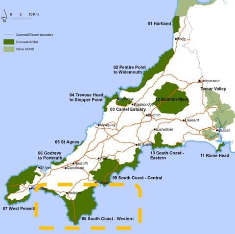
The project team decided to use Section 08 of the Cornwall AONB as the defined landscape for its test trial. Section 08 comprises the southwest Cornwall coast, the Lizard Peninsula and the Helford Estuary. It was chosen out of the 12 sections of Cornwall AONB, which are separate areas dispersed across Cornwall, for several reasons.
Firstly, Section 08 is relatively large area of the AONB that covers 192 km2 and has many habitat types, including enclosed farmland, moors and coastal margins. It also hosts several nature reserves and has an established statutory forum called ‘Linking the Lizard’, which was set up to bring landholders together to discuss the coordination of conservation efforts. Many different initiatives had therefore already taken place or were underway to explore natural capital improvements, such as the Farms for AONBees programme. The project team were therefore able to identify the local stakeholders who would want to support this scheme, and use an existing knowledge base across these programmes and initiatives in the project.
Another factor that made Section 8 suitable was the historic nature loss across the area. Despite its many statutory conservation designations, the project team had found that Section 08 had seen a net loss of biodiversity across nearly every genus of animal for the last 20 years. The team found this by examining the Species Richness Index data from the local environmental records centre, and working with the Cornwall Wildlife Trust, who were undertaking an ecological assessment for their State of Nature Cornwall 2020 report. There was therefore a need for nature recovery that wasn’t being met with existing measures and regulations.
The project team concluded that this combination of factors made Section 08 optimal for the test trial, and if this work could not be executed in this Section then it was unlikely that it could be achieved elsewhere in the AONB.
Natural capital accounting
The initial natural capital account was conducted by Gain Consulting, who began with a ‘top down’ analysis of Section 8. Colette Beckham, Director at Gain, led this work over an eight month period. She started with the Cornwall Land Cover dataset, a GIS dataset derived from detailed aerial photography. This dataset was originated by the Cornwall Wildlife Trust in 2005 and made available via Cornwall Council. Beckham used this dataset in QGIS, , a free open source GIS system, to develop a detailed natural capital map and profiles for the area.
Beckham comments that an early risk identified was that this dataset had not been updated in many years. However, the ‘ground truthing’ work directly with farmers (see below) showed that there had been minimal changes in land use since 2005. The team also added other datasets to this map, including satellite derived, digital mapping from the University of Exeter on wetland and woodland creation opportunities, and the Habitat Networks map that was originated by Natural England. These additional sources were used with the natural capital mapping to scope the types of intervention most appropriate in the landscape to recover ecosystem services.
Another limitation of this study was that there was no comprehensive data on the quality of these habitats, and the project team agreed that this information would need to be captured in later work.
Through this work, a map was drawn together that gave a breakdown of each natural capital type and land cover in terms of hectares. To understand the current economic value of these habitats, the project team then focused on five ecosystem services for each natural habitat type – water quality, water regulation (flood attenuation), wild species diversity, carbon storage and carbon sequestration.
Beckham and the team then conducted a value transfer exercise, taking studies in other areas of the UK that gave economic values per hectare of habitat, and then applying these to the Section 08 map. The team mainly used primary valuation studies that had been conducted in other areas, largely by universities. Several assumptions needed to be made in this exercise, and the team advocated for more Contingent Valuation and Willingness To Pay (WTP) studies to be conducted in the UK, and in Cornwall specifically to increase accuracy. For example, on request from the farmers it was working with, the team attempted to include the ecosystem services provided by the extensive network of Cornish Hedges in the landscape, but unfortunately there were no primary values for ecosystem services delivered by this natural capital type, which the team called out as a critical knowledge gap.
Overall, it found that the existing natural capital stock held a value of £104m – £519m over a 10-year period, with water quality being the most highly valued ecosystem service.
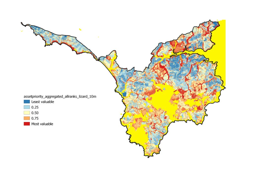
Ecosystem services asset priority map (aggregated) © Crown
copyright and database rights 2020 Ordnance Survey 100049047
Identifying target land use with farmers
Alongside this ‘top-down’ account of Section 08’s current natural capital, the project aimed to establish targets for restoring natural habitats and co-designed a Landscape Recovery Framework with farmers in Section 08. This framework would quantify the objectives over the next 10 years and also set out how farmers could work together to achieve these.
To do this, the project team drew together a ‘cluster group’ of farmers within Section 08. In developing the Landscape Recovery Framework with this group, it also aimed to create individual farm-action plans that showed how the strategic framework could be delivered on individual farm holdings, while exploring what revenue streams would be possible for the farmers (see below).
The project team were already familiar with many farmers in Section 08, having worked with some of them in previous ecological studies and initiatives like Farms for AONBees. It therefore had an established contact list and a strong working relationship with farmers who had appropriate expectations as to the level of work that would be required in the test trial.
The project team invited farmers from across Section 08 to a series of virtual and in-person workshops in the first nine months of 2020. These initially focused on discussing the aims of the project and sharing findings from the data gathered to date. The project team felt that getting farmers comfortable with the natural capital data was an important first step in encouraging co-design. The team also sent out a questionnaire via Survey Monkey , asking farmers to rank their top five objectives from a long list of 24 natural capital objectives that had been co-developed with the farmers
One of the early design principles identified was that farmers were reluctant to discuss ‘spatial prioritisation’ in targets, as they didn’t want to draw “lines on maps” to be disadvantageous to themselves or their neighbours. However, as the trial progressed, the farmers became more open to the use of maps in deciding target land use, although still preferring a gradient approach to indicate strength of opportunity, rather than a defined line. “A spray-painted line would be better” is how one of the farmers referred to it. The farmers also preferred ‘in-rotation’ changes that they embed within their farming activities on land within production, rather than committing to permanent land use changes.
Beckham states that the Covid-19 pandemic severely limited the methods by which they were able engage with the farmers. Similarly, key partners such as the National Trust had not been able to participate as early because staff had been furloughed. However, with a series of live and recorded workshops, surveys and other forms of communication, the team established a regular group of 11 farmers for their core working group along with representatives from the National Trust, Cornwall Council, the Environment Agency, Natural England, and other key stakeholder organisations.
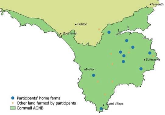
Farm locations within the project area © Crown copyright and database rights 2020
Ordnance Survey 100049047
Over August and September, the project team and these farmers met three times and over several hours co-designed the Landscape Recovery Framework – addressing the question of what land use changes should be prioritised and ‘how much’ could be achieved through both rotational and permanent land use change.
The Landscape Recovery Framework was published in January 2021 to reflect this work, including the objectives that were agreed with the farmer group. These objectives cover the next 10 years, some examples include:
– Creating 1km of new Cornish hedges per year
– 20% increase in the total area of ponds
– 80% of rotational land in species-rich options, such as herbal leys
– 5% of new stream valley woodlands
– Certifying 3% of the total area of agricultural land as organic
– Creating 20 new hectares of heathland
Creating individual farm action plans
The project team used the objectives set in the Landscape Recovery Framework to then create ‘farm action plans’ with three different farmers, which would show how these objectives could be delivered on a farm-basis. It then estimated what payments might be needed to incentivize these farmers and explored the public and private options.
Dr Grace Twiston-Davies from the University of Exeter led this exercise, and started to gather data for the case study farms in April 2020. Farmers with representative farm types were invited from the trial group, and three were selected, each with a total farm holding area of between 44 and 90 hectares.
Twiston-Davies produced a current spatial view of each farm on QGIS and built in an understanding of current and planned land management activities for the next 4 years through discussions with the farmers, such as rotational cropping activities. These maps served as the baseline to the farm action plans.
Twiston-Davies then conducted several site visits and interviews with the farmers to determine where the objectives from the Landscape Recovery Framework would be best applied. This led to the creation of a ‘farm opportunities map’ which can be seen as a final spatial plan of each farm. This was drawn up in a draft and agreed with each farmer, again using QGIS.
Across the 220 hectares of the three farms, the opportunities identified with the largest areas were:
– species-rich herbal leys with 97 hectares
– wood pasture and orchards with 17 hectares
– wetland and wetland buffering with 11 hectares and 5 large ponds
Determining payments needed on a farm-basis
After these opportunities were identified, the project team then calculated what payments would be needed and what value of ecosystem services they would deliver. It estimated how these objectives would be funded by the existing Countryside Stewardship (CS) scheme, how much the farmers would need to be incentivised to make these changes – the ‘asking price’ – and the total public goods value that these objectives would deliver.
This exercise found that the current payments under the existing CS scheme were insufficient and farmers were very unlikely to make the land use changes with only these. On average, there was a c.£200 / ha / year funding gap between the highest payments possible from the CS scheme and the asking price from the farmers.
Using the same methodology as used in the ‘top down’ natural capital account, the estimated value in ecosystem services generated from these changes was around three times higher than the asking price of the farmers. The project team concluded that if Defra were to fund these changes with payments attractive to farmers, it could expect a return of £3 for every one pound spent.
Over the entire Section 08, the project team concluded that an additional £3.7m – £15.8m in public goods would be generated if the Landscape Recovery Framework was achieved. Most of this additional value would come from improved water quality (£2.9m – £10.9m), however the team highlighted that the value of wild species biodiversity was a gross underestimate given the lack of data and understanding of how other ecosystem services were underpinned by biodiversity.
Conducting an initial beneficiary analysis
While these findings were submitted to Defra as part of the Test Trials, the project team saw that a natural continuation of this project was to explore a blended public-private funding structure, to help meet any difference between farmer payments and the new ELM schemes.
Within the defined area of Section 08, the project team listed high level reasons why entities would be interested in paying for certain ecosystem services, such as reduced risk of flooding, biodiversity impact mitigation, or offsetting carbon emissions. It then looked across six groups of ecosystem services and predicted what local entities would have an interest in each these. The entities included South West Water, Cornwall Council, local energy companies, insurance providers, private healthcare providers, and tourism businesses.
However, the team then looked at existing market infrastructure and determined that only two mechanisms were sufficiently developed to channel these payments – biodiversity net gain and carbon offsetting, which both had limitations in terms of scope and usability alongside public subsidy schemes.
For example, with a 5% increase in stream valley woodlands, the team estimated that Section 08 might be able to generate between £43,750 and £180,000 in income over a ten-year period from the sale of Woodland Carbon Code credits. However, the carbon sequestration value from pastures, hedges, sustainably managed farm soil and other sources could not be eligible via WCC. However, farmers were most interested in these carbon stores.
The project team concluded that further ways of channeling payments for ecosystem services should be identified to help meet the objectives of the Landscape Recovery Framework, alongside a government subsidy scheme that values the restoration and maintenance of natural capital.
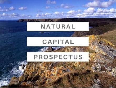
On behalf of the project team and the Cornwall AONB Partnership, Gain Consulting published a Natural Capital Prospectus in January 2021, which called for businesses and other entities to consider payments for these ecosystem services. It also explored the potential for the creation of the ‘Lizard Landscape Recovery Fund’, administered by the Cornwall AONB Trust, as the elected vehicle for these payments. Carbon units via the Woodland Carbon Code and Biodiversity Net Gain (BNG) units were referenced as an initial offer.
Funding for project development
To further develop this work, the Cornwall AONB Trust and the wider project team submitted a grant funding application for the Natural Environment Investment Readiness Fund, when the scheme was first announced in January 2021.
The application took two months to write, and outlined a development plan to create an ‘ecosystem services market’ within the Cornwall AONB. The application proposed that these former Test Trials served as the ‘Discovery’ phase of the project, and that the NEIRF grant would be used to fund the ‘Structuring’ phase which would examine the feasibility of attracting private finance and the potential governance and deal structures necessary to achieve investment. It also set out three further stages of project development: Further Development, Financing and Monitoring – which it made clear would each take at least a year and would require further funding.
The application was approved and £99,500 in grant funding from Defra was confirmed in July 2021.