Project Overview
The Eddleston Water Project is a flood resilience and habitat restoration project near Peebles, Scotland. The project was started in 2010 primarily to reduce flood risk and restore habitats at a catchment scale, and ultimately to gather an evidence base on the effectiveness of natural flood management for wider use. Measures implemented across the 69km2 catchment include the creation of 38 new ponds, the re-meandering of some 3.5km of once-straightened river channels, 100 engineered log structures to slow excess water, and the planting of over 330,000 native trees.
While the project was predominantly funded through grants from the Scottish Government, the Scottish Environment Protection Agency and a number of other funders, the project team also sold a small number of carbon credits from its native woodland creation through the Woodland Carbon Code. In February 2023, the project was chosen as a UNESCO Ecohydrology Demonstration Site, the only one in the UK.
Acknowledgements
With many thanks for their time and insight on this case study:
Luke Comins, Chief Executive Officer, Tweed Forum

Professor Chris Spray, Emeritus Professor of Water Science and Policy, University of Dundee
![]()
Date published: 26/05/2023
Project Mandate
The Eddleston Water is a tributary of the River Tweed in the Scottish Borders, located within a catchment of 69 km2 that drains south to the Tweed at Peebles. It has a mix of forestry, rough grazing and improved grassland, arable and peatland. Part of the catchment is also designated as an EU Special Area of Conservation (SAC) for its salmon, lampreys, otters and aquatic plants. However, the river was classified by SEPA at ‘bad’ ecological status in 2009, using the EU Water Framework Directive (WFD) criteria, largely on account of historical changes to its banks and channel
The catchment has also seen a significant increase in flooding. SEPA’s flood risk assessment shows some 582 properties are at risk of flooding in Eddleston and Peebles under a 1:200 year scenario, but there have been several flooding incidents that have drawn attention to the lack of flood resilience within the catchment. Over the last 200 years, the river has been extensively channelised and straightened, losing up to 16% of its length and with embankments and drainage installed alongside it.
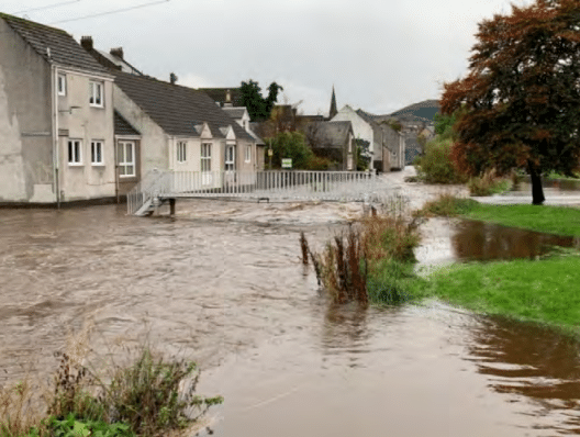
Peebles Village – October 2021
Given these characteristics, the Eddleston catchment was selected as Scottish Government’s main empirical research study of the effectiveness of Natural Flood Management (NFM) managed by Tweed Forum, in partnership with the Scottish Government and SEPA. Representatives from these organisations met at a flood-focused conference a year before and identified the lack of evidence proving NFM could be a cost-effective measure to reduce flood risk as a major challenge to implementation; something highlighted earlier in 2009 by a Scottish Parliamentary Inquiry into flooding policy.
At the time, Scotland’s Flood Risk Management Act (2009) was being developed and the Scottish Government recognised the need for a stronger evidence base for NFM. The Act (Section 20) requires that for any Flood Scheme being developed, one must assess to what extent and how the ‘natural characteristics’ of a catchment can also help reduce flood risk.
Luke Comins, Director of the Tweed Forum, said that the group wanted to create a “catchment laboratory” to start shedding light on this issue, and act as a forward-thinking advocate for the ‘upstream approach’ of natural flood management, rather than, but alongside traditional infrastructure flood defence measures.
The project’s aims were to:
- assess the effectiveness of NFM measures to reduce flood risk
- assess the impact of NFM restoration on habitats and species
- work with landowners and the local community to maximise the benefits to them, while sustaining farm businesses
Assessing the current state of the land
Before doing anything, in 2010 the University of Dundee as the Project’s main research provider produced a scoping study that identified potential NFM measures that theoretically could be introduced. Working with cbec ecoengineering, this included a characterisation of the river and catchment, utilising existing information on land use, ecology and hydrology, as well as a new ‘fluvial audit’ field-mapping physical condition through the system.
The Scoping study also included the production of a Monitoring Strategy and a Stakeholder Engagement strategy. In 2011 the project team set up a comprehensive hydrological and ecological Monitoring Network to measure the effects of the NFM interventions. This includes a comprehensive array of instruments across the whole catchment measuring rain and other weather parameters, river levels and flows, groundwater and soil moisture to identify how and where flood runoff is initiated and how floods then move downstream.
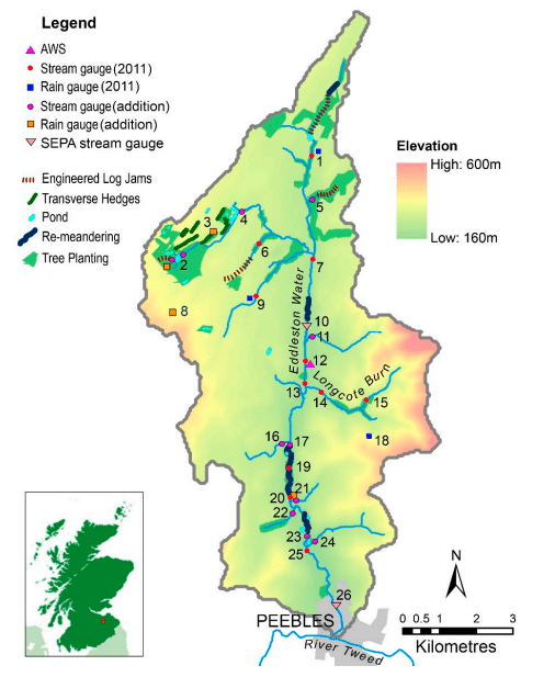
Eddleston catchment map showing location in Scotland (inset), NFM measures and numbered locations of hydrology monitoring instruments
The team gathered two years of baseline data before undertaking any capital works, including one year which saw the highest recent river levels on record. This initial data showed a complex interaction between surface water and groundwater, with a significant contribution of groundwater to localised flooding that Comins notes was a valuable learning of this early study and key for planning the NFM interventions.
Alongside collecting hydrological data, the project team also undertook ecological surveys of aquatic invertebrates, plants and fish at a whole catchment scale to assess the health of the river’s biology. More detailed ecological surveys were also undertaken at two locations where the river had been re-meandered (and two control sites) to assess the impact of re-meandering on channel structure and riparian ecology.. Over the course of the project, these surveys have been repeated to demonstrate the recovery of the river and any uplift in biodiversity as a co-benefit.
Determining appropriate change in land use
Based on the information gathered, the catchment would benefit from a network of re-meandered rivers, high-flow log restrictors, riparian tree clusters, ‘leaky’ ponds and restored peatland, from an NFM and habitat restoration point of view. These would be placed strategically based on the hydrological analysis, current land management practices and historical context of the area. For example, it was theorised that high-flow log structures would be best placed in headwater streams, and ponds in the upper parts of the catchment would store water in floods and storms.
However, the project team understood these measures would only be effective as a whole if implemented at scale across the whole catchment, and landowner agreement was naturally key to this implementation. Along with the Monitoring Network, the project team undertook a series of interviews and surveys to assess farmers’ attitudes, cost-benefit analyses, income foregone, and land use strategy. It also consulted the 30 or so farmers to ask their views on what and where NFM measures may be best suited, incorporating their local knowledge of the catchment. Comins highlights this as a valuable part of the project’s design.
Funding project development
This initial phase of work was managed by the Tweed Forum, and directed by a small Project Board chaired by the Scottish Environment Protection Agency (SEPA) and the Scottish Government, with the University of Dundee as the main Science provider. This initial phase took around two years, and costs totalled £355,000, including the feasibility study, the Monitoring Network, baselining and engagement with farmers. This first phase was predominantly funded by the Scottish Government.

Over the course of the study, the Project Board has expanded to include the Scottish Borders Council, with the British Geological Services as a second main science provider alongside Dundee university. The project also has a Steering Group, set up to provide advice and support, including the NFU (Scotland), Scottish Land & Estates, the, Forest & Land Scotland, Environment Agency, Forest Research, Tweed Commissioners and NatureScot.
Further costs over the following 15 years included the full monitoring, evaluation and modelling of the project (£1,157,342), and the design and capital works of the NFM practices (£1,251,265). Total costs were c.£2,800,00, though ‘help in kind’ was a significant component of the project’s resources. Notably, this included time from SEPA, which undertook all the extensive hydromorphological and ecological monitoring, and the University of Dundee, which allocated several fully funded PhD and master’s students. Other universities also dedicated such resources.
The majority of funding came from the Scottish Government and the EU Interreg Programme (for ongoing monitoring). However, the project also secured grants from a variety of sources, including SEPA, the Forestry Grant Scheme, the Nature Restoration Fund (NatureScot), Scottish Power, CEMEX, the Woodland Trust and some carbon finance. Comins highlights that this project has undertaken extensive scientific and ecological research to provide an evidence base and blueprint for other NFM projects. The overall aim of the project is to serve as a ‘typical’ catchment and share learnings with other sites and locations.
While the main focus of the project was NFM, the team also emphasised the other ecosystem service gains, such as biodiversity, amenity value, carbon sequestration and water quality. Comins recommends that other projects gather supportive information on such co-benefits to improve their chances of securing funding.
Sources
- Interview with Luke Comins, Tweed Forum and Professor Chris Spray, University of Dundee
- Eddleston Water Project Database, Tweed Forum