Overview
The Bwlch Y Groes peatland project is the first project in Wales that has used a blend of public funding and carbon finance to restore degraded peatland. This was achieved via the IUCN UK Peatland Carbon Code. The site covers 66 hectares in Bwlch Y Groes, on the edge of Snowdonia National Park. The site has been owned by the Roberts family for several generations, who predominantly focus on beef and sheep farming.
Acknowledgements
With thanks for giving their time and insight to this case study:
Lisa Roberts, Farmer, Pennant Farm
Rachel Harvey, Peatland Officer, Snowdonia National Park Authority

Date published: 08/12/2022
Origin of the project
Lisa Roberts and her husband participate in several agri-environment schemes, including a Wales-based pilot that explores ways for farmers to develop their natural capital.
As part of this pilot, in 2018, the Roberts family explored the use of the farm’s peatland, including one site covering a 66-hectare degraded peatland. Roberts noted: “at the time, it seemed strange that others were using relatively small parcels of woodland under the Woodland Carbon Code, but we had a lot of peatlands that we weren’t looking at as closely.” Roberts undertook some desk-based research on ways to restore peatlands and funding sources.
She came across the IUCN Peatland Programme and its recently launched Peatland Code in her initial research on this topic (see below).
After this, Roberts connected with an officer at Snowdonia National Park Authority (SNPA), Rachel Harvey, who was seeking a farming partner to trial peatland restoration using the Peatland Code. After the Roberts’ agreement to participate, Harvey was assigned with leading the process, including the site surveying and project design.
![]()
Use of the Peatland Code
The Peatland Code is a voluntary standard that allows owners of degraded peatlands, which emit significant carbon, to restore these using funds from ‘carbon units’ sold to private buyers. It was launched in 2016. The Peatland Code’s ambition is to help restore and sustainably manage the UK’s two million hectares of peatland.
The Peatland Code offered the Bwlch Y Groes project several advantages. It specifies a scientific methodology for assessing the current state of peatlands and how much carbon can be avoided. It measures this in tonnes of ‘CO2 equivalent’ (CO2e), the key metric on which sellable units are based.
The Peatland Code also mandates a set of processes and features that safeguard the robustness of peatland restoration projects, which increase buyer confidence. This includes processes on monitoring, reporting and verification (MRV), community engagement, additionality and certification of projects by an independent body. It also hosts units on the UK Land Carbon Registry, so that units are not ‘double counted’ by separate buyers.
Baselining
The project team needed to survey the peatland site as part of the project’s design, involving both ground surveying and desktop mapping. Harvey, the Welsh Peatlands Sustainable Management Scheme (SMS), UK CEH and Natural Resources Wales have since developed a Rapid Assessment Protocol for peatland project developers.
Desktop mapping initially took around four hours. Harvey first used several different aerial images to identify the site and annotate a ‘site map’ with details such as the site boundaries, access points and notable features. She also noted the GPS co-ordinates in GIS for where the team would need to take peat depth measurements and assess the peat condition and vegetation. This would then be taken out on the field survey using a GIS app, although she notes a spreadsheet and GPS can also work well. As per the Peatland Code baselining process, the survey points are determined via a grid of 10m x 10m plots overlayed on the map, with each survey point spaced 100m apart.
The ground surveying of the site then took around four days. Harvey herself took down information at c.68 survey points over 90 hectares – though she notes that this would likely have been achievable over one to two days with two people. She used a peat probe for measuring soil depth, and a mobile phone for tracking GPS co-ordinates, taking pictures at each survey point, and recording information. Harvey also recommends noting what vegetation and wildlife during a peat survey, such as cotton grass, sphagnum and heather (a brief identification guide is included in the Rapid Assessment Protocol).
Photo credit: DEYA Brewing Co
The ground surveying confirmed that the site was eligible under the Peatland Code. Of the 90 hectares within the mapped site, 66 hectares were classified as blanket bog with peat soils of over 0.5m depth across 70% of the survey points. The condition of the peatland was confirmed as a mixture of ‘actively eroding’ and ‘drained with haggs and gullies’, as defined by the Peatland Code.
Using this field data, Harvey returned to the virtual site map and annotated it further to show peat depths, conditions and other notable features across the site. This took about two hours to complete. You can find a copy of the site map here.
Harvey has since put together a ‘How To’ Guide for navigating the Peatland Code process.
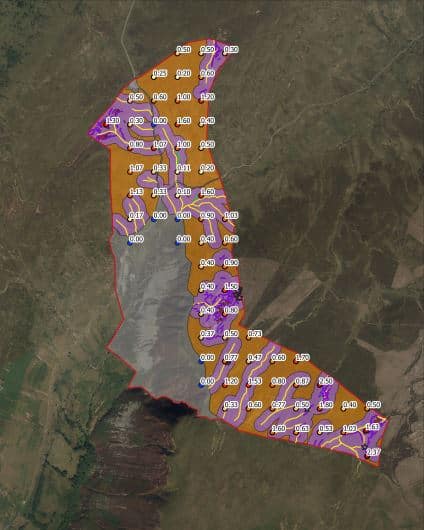
Bwlch Y Groes Site Map, Peatland Code Registry
Restoration planning
The field data confirmed the peatland site’s current state, which allowed the team to proceed with restoration planning. However, there were elements to clarify with the Roberts family to get them comfortable with the project.
Firstly, the duration of the project needed to be agreed. Sites under the Peatland Code must be maintained for 30 years minimum. The Roberts family, who had owned the site for several generations, agreed to commit to 35 years. “Luckily, we’re a young family and we plan to retain ownership of the farm, so we were able to get comfortable with this aspect,” comments Roberts.
The Roberts family also want food production to remain the central activity of Pennant Farm and addressed any potential conflict during the restoration planning. “As one of the first movers in this space, we wanted to show that peatland restoration can be done alongside sustainable food production,” says Roberts. The peatland is used as rough grazing for livestock, but because the area is an SSI protected site and stocking densities are regulated, there was no need to reduce the number of grazing animals.
To build the restoration plan fully, Harvey spoke with several peatland specialists at the SNPA, National Resources Wales, the Centre of Ecology and Hydrology, Swansea and Aberystwyth Universities, and the Peatland Code team itself. Designing the full restoration plan, including the formal Project Design Document, took roughly two months – though Harvey notes with more experience that it can now take as little as a week.
The restoration activity focused on reprofiling the eroding haggs, with one main gully blocked for rewetting and some re-vegetating of bare peat. The project team contracted an experienced peatland contractor to lead this process. It chose this company via a tender process ran with Sell2Wales. Roberts comments that the restoration work went smoothly over several weeks in January 2019 with no notable issues, assisted by the road access to the site and mild weather conditions at the time.
Across 35 years, the restoration will have prevented over 2,335 tons of CO2,e from entering the atmosphere, with an equivalent 2,355 units being verified over this time.
Harvey has also since developed Peatland Restoration Methods guide to share her learnings.
Monitoring and maintenance
The Peatland Code requires a monitoring and maintenance plan to be submitted alongside the restoration plan.
Different levels of monitoring are undertaken by the Roberts family and the SNPA. The Roberts family handle informal monitoring of the site, including visual checks over the hagg complexes and the gully block. The SNPA undertake more detailed reviews, including the monitoring reports required by the Peatland Code, and the verification points that confirm the carbon emission reductions have been achieved, allowing buyers to use the carbon units for offsetting. More regular monitoring is planned for the first five years of the project, as this is when the peatland restoration activities are at highest risk of reversal.
As for maintenance, the Roberts family is in charge of any necessary maintenance activity, and costs are built into the financial model of the project. As a rule of thumb established by Harvey’s research, lifetime maintenance costs are estimated to be 10% of the upfront restoration costs. The Roberts family had initial concerns about being able to maintain the peatland without a formal skillset, but Harvey and the SNPA have agreed to provide advice and support on this where needed. Harvey says that while the SNPA team will help where it can, it could not contractually commit to the full 30 years, and therefore Roberts signed an agreement with National Resources Wales to officially help with monitoring over the long-term.